Trilha Inca
Uma aventura pelo caminho do Sol
PT USD  

Mapas da Trilha Inca

Mapas da Trilha Inca
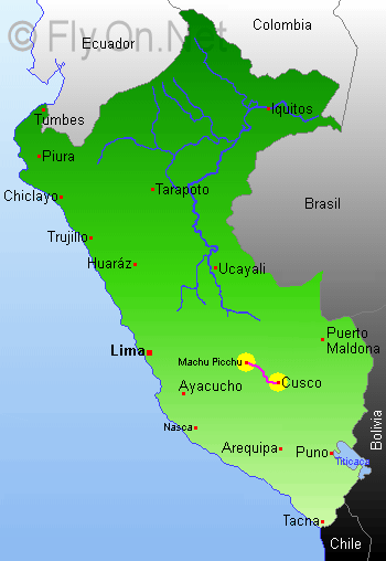
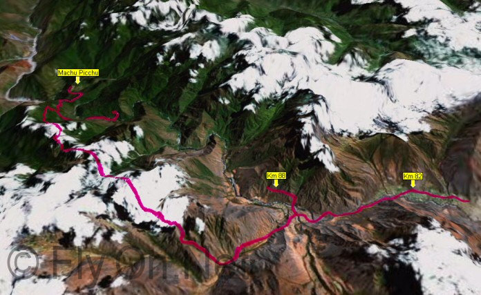
A Trilha Inca está localizada nas alturas dos Andes peruanos, entre Cuzco, a capital do antigo Império Inca, e a cidadela de Machu Picchu.
Mapas da Trilha Inca
A alternância de montanhas e vales ao longo da trilha oferece uma vista impressionante e muito diversificada.
Mapas da Trilha Inca
Mova o cursor em um lugar para ver os detalhes. <h3>Wiñay Wayna</h3><img width=180 height=120 src='/general/images/maps/camino/winay_wayna.jpg'> <h3>Aguas Calientes</h3><img width=180 height=120 src='/general/images/maps/camino/aguas_calientes.jpg'> <h3>Wayna Picchu</h3><img width=180 height=120 src='/general/images/maps/camino/wayna_picchu.jpg'> <h3>Machu Picchu</h3><img width=180 height=120 src='/general/images/maps/camino/machu_picchu.jpg'> <h3>Chakicocha</h3><img width=180 height=120 src='/general/images/maps/camino/chakicocha.jpg'> <h3>Punkurakay</h3><img width=180 height=120 src='/general/images/maps/camino/punkurakay.jpg'> <h3>Llaqtapata</h3><img width=180 height=120 src='/general/images/maps/camino/llaqtapata.jpg'> <h3>Wayllabamba</h3><img width=180 height=120 src='/general/images/maps/camino/wayllabamba.jpg'> <h3>Llulluchapampa</h3><img width=180 height=120 src='/general/images/maps/camino/llulluchapampa.jpg'> <h3>Qorihuayrachina</h3><img width=180 height=120 src='/general/images/maps/camino/qorihuayrachina.jpg'> <h3>Q'ente</h3><img width=180 height=120 src='/general/images/maps/camino/qente.jpg'> <h3>Sayacmarca</h3><img width=180 height=120 src='/general/images/maps/camino/sayacmarca.jpg'> <h3>Conchamarca</h3><img width=180 height=120 src='/general/images/maps/camino/conchamarca.jpg'> <h3>Intipunku</h3><img width=180 height=120 src='/general/images/maps/camino/intipunku.jpg'> <h3>Phuyupatacamarca</h3><img width=180 height=120 src='/general/images/maps/camino/phuyupatacamarca.jpg'> <h3>Intipata</h3><img width=180 height=120 src='/general/images/maps/camino/intipata.jpg'>
Mapas da Trilha Inca
Mapa de Machu Picchu - Coloque o cursor em cima de um lugar para ver o detalhe. <h3>Templo da Lua</h3><img width='180' height='120' src='/general/images/maps/machu/templo_luna.jpg' /> <h3>Group of the top</h3> <h3>Sacred Stone</h3><img width='180' height='120' src='/general/images/maps/machu/roca_sagrada.jpg' /> <h3>Grupo de três portas</h3><img width='180' height='120' src='/general/images/maps/machu/tres_portadas.jpg' /> <h3>Área industrial</h3><img width='180' height='120' src='/general/images/maps/machu/sector_industrial.jpg' /> <h3>Main Plaza</h3><img width='180' height='120' src='/general/images/maps/machu/plaza_pal.jpg' /> <h3>Cemitério</h3> <h3>Intihuatana</h3><img width='180' height='120' src='/general/images/maps/machu/intihuatana.jpg' /> <h3>Templo Principal</h3><img width='180' height='120' src='/general/images/maps/machu/templo_pal.jpg' /> <h3>Royal Palace</h3> <h3>Fountains street</h3><img width='180' height='120' src='/general/images/maps/machu/escalera_fontanas.jpg' /> <h3>Central Stairs</h3><img width='180' height='120' src='/general/images/maps/machu/escalera_central.jpg' /> <h3>Temple of the Three Windows</h3><img width='180' height='120' src='/general/images/maps/machu/tres_ventanas.jpg' /> <h3>Quarry</h3><img width='180' height='120' src='/general/images/maps/machu/cantera.jpg' /> <h3>Bird sculpture</h3> <h3>Watchman\'s Hut</h3> <h3>Funerary rock</h3><img width='180' height='120' src='/general/images/maps/machu/roca_funeraria.jpg' /> <h3>Barracks</h3> <h3>Pain doorway</h3><img width='180' height='120' src='/general/images/maps/machu/puerta.jpg' /> <h3>Temple of the Sun</h3><img width='180' height='120' src='/general/images/maps/machu/templo_sol.jpg' /> <h3>Watchmen houses</h3><img width='180' height='120' src='/general/images/maps/machu/casa_vigilante.jpg' /> <h3>Doorways Group</h3> <h3>Peripheral stairs</h3> <h3>The Prison</h3><img width='180' height='120' src='/general/images/maps/machu/carceles.jpg' /> <h3>Houses of the Noble</h3><img width='180' height='120' src='/general/images/maps/machu/casas_nobles.jpg' />